Salt Lake West Side Stories: Post Two
By Brad Westwood
This post clarifies the traditional boundaries of Salt Lake City’s Pioneer Park neighborhood or, the original west side. It also defines terms used throughout the series when discussing geographic locations.
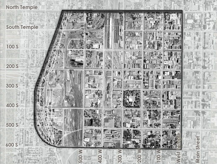
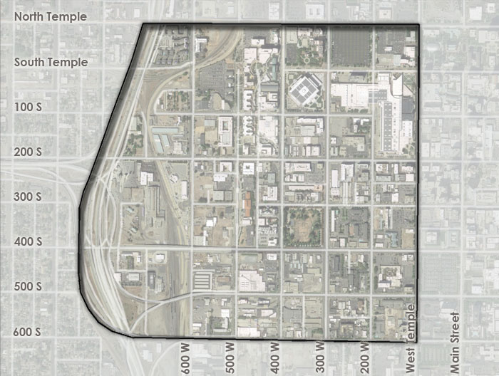
When we discuss Salt Lake City’s original west side, we refer to a specific geographic area. The boundaries are as follows: North Temple Street marks the northern border, and 600 South is the south boundary. West Temple is the east boundary, and the Interstate-15 freeway and railroad corridor (between 500 and 800 West) is the west boundary. See the two adjacent expanding aerial photographs, the first dating to 1958 and the second taken in 2015, to visualize the borders. Sometimes we will include subjects and stories integral to the neighborhood’s story that extend beyond these boundaries. These posts demonstrate the fluidity of culture, identity, and human interaction in the Salt Lake City and Salt Lake Valley. The borders, and the stories told within them, are not hard lines, but permeable, making the west side connected and influential to Utah’s political, cultural, and economic identities.
An explanation for the use of the “west side”: In the nineteenth and early twentieth centuries, Salt Lake City’s “west side” meant something entirely different than it does today. Today, and for the last century, the term “west side” describes areas west beyond the Jordan River, including Glendale, Rose Park, Poplar Grove, and West Pointe. Up until World War I (ending in 1919), the “west side” encompassed the area from West Temple to the railyards. Before 1919, industrial lots, farmland, a scattered agricultural business, and residential developments occupied the lands west of the railyards. For this project’s purposes, we will use “Pioneer Park neighborhood” and the historical “west side” titles interchangeably as we examine the history of Salt Lake City’s diverse old western section.
Names, Names, and More Names: Over the years, the Pioneer Park neighborhood has had many informal and formal titles. Different names are associated with the various peoples living, speaking, and holding power in the area at any given time. People have referred to the area as “poor town,” “Little Italy,” “Greek Town,” “Little Syria,” “Japan Town” or “Little Tokyo.” Other names include “the old west side,” “the Warehouse District,” the Wholesale District,” “the Depot District,” “the Hardware District,” “the Station Center,” “the Post District,” and “the Rio Grande District.” As you can see, the neighborhood meant many things to different people over the years, and you will learn about these identities in this blog series. Many of these named geographical and cultural locations were bordered, replaced, or overlapped by one another.
Pacific Islander Communities (an exception to the above boundaries): Salt Lake’s west side also included the north section of Salt Lake City near the Wasatch Hot Springs. During the 1870s and early 80s, Maoris from New Zealand, Tahitians, and Hawaiians gathered in this then poverty-stricken area. Prior to Mormon (members of The Church of Jesus Christ of Latter-day Saints, hereafter LDS Church) settlement the area surrounding the hot springs were used for seasonal camps for Native Americans. During the late nineteenth and early twentieth century, the northwest side also became the location of several industries that included sand and gravel excavation. Railroad companies also chose the northwest side as a transportation hub. For example, the Oregon Short Line’s yard and roundhouse (part of the Union Pacific system) along with other railyards were built in the area of 700 to 1200 North and 500 to 70 West. Ostensibly this area is part of Salt Lake’s west side.
Pacific Islanders did not reside in Salt Lake’s northwest side for long. As folklorist Carol Edison notes, Pacific Islanders faced “marked cultural differences [that] inhibited their integration.” Not only did the Pacific Islanders struggle with culture shock, but they also faced severe discrimination and health scares that exacerbated tension between them and Salt Lake’s white community. In 1889, in response to the discrimination that Pacific Islanders faced, the LDS Church purchased ranchlands in the very dry and barren Skull Valley located 25 miles southwest of Salt Lake City. The LDS Church urged Pacific Islander LDS Church members to resettle on the new church-owned ranch, which the Pacific Islander community renamed Iosepa, a Hawaiian form of “Joseph” named after the LDS Church’s prophet, Joseph F. Smith.
“People have referred to the area as ‘poor town,’ ‘Little Italy,’ ‘Greek Town,’ ‘Little Syria,’ ‘Japan Town.’ Other names include ‘the old Westside,’ ‘the Warehouse District,’ ‘the Depot District,’ ‘the Hardware District,’ ‘the Station Center,’ and ‘the Rio Grande District.’”
After the LDS Church opened a temple in Hawaii in 1915, LDS Church leaders encouraged members of the community to return to their Pacific Island homelands. A majority of the Pacific Islanders did choose to return to the place of their nativity.
By World War II, the LDS Church had grown substantially in the Pacific Islands. After the war ended, thousands of Hawaiians, Tahitians, Samoans, Tongans, and other Pacific Islanders left their homes to settle mainly along Utah’s Wasatch Front. More specifically, a majority found homes in Utah’s “new” west side communities, located west of the Jordan River across the Salt Lake Valley.
A Note on Street Names and Renumbering: In 1973, the streets north and west of Temple Square (west of West Temple Street and north of North Temple Street) were renumbered to align with the existing lot or building addresses. For example, 100, or “First West,” became 200 West (which made West Temple also 100 West), and “Second West” became 300 West. This has created no end to confusion, especially when researchers are reading documents produced before 1973. In Salt Lake West Side Stories, all street names use the post-1973 names (or numbering) system to allow readers to connect with the current physical space.
As you can see, Salt Lake’s west side has a diverse and rich history. As you read each post and interact with the images and other materials, you will have the opportunity to interact with the previously mentioned themes and the boundaries described above. Don’t forget to look again at the two aerial photographs, likely, you’ll be coming back to them, as you read subsequent blogs.
Would you like to read the next post (Post 3)? Eight Themes Offered
Click here to return to the complete list of posts.
Related Activity: Walk, bike, or drive around the Pioneer Park neighborhood’s boundaries (North Temple, West Temple, 600 South and in and around Interstate-15 and the railroad right-away back to North Temple) to get a sense of the neighborhood’s size and geography. Touring the neighborhood’s boundaries is not easy, but it is worth it to get a sense of space and a feel for the neighborhood as you continue reading the SLWSS serial blog.
Contributors: This post was researched and written by Brad Westwood with a whole lot of help from friends. Thanks to our sound engineer and recording engineer Jason T. Powers, and to his supervisor Lisa Nelson, both at the Utah State Library’s Reading for the Blind program. Thanks also to yours truly, David Toranto, for narrating this post.
Selected Readings:
Carol Edison, “South Sea Islanders in Utah,” Utah History Encyclopedia (1994).
Richard L. Jensen, “Immigration to Utah,” Utah History Encyclopedia.
Matthew Kester, Remembering Iosepa: History, Place, and Religion in the American West (New York: Oxford University Press, 2008).
Do you have a question or comment? Write us at “ask a historian” – askahistorian@utah.gov